Sw 8 St @ Sw 36 Ct stop - Sunday schedule
| Line | Direction | Time |
|---|---|---|
| 8 | 8 - Fiu South Terminal | 6:21 AM |
| 8 | 8 - Fiu South Terminal | 7:22 AM |
| 8 | 8 - Fiu South Terminal | 8:22 AM |
| 8 | 8 - Fiu South Terminal | 8:52 AM |
| 8 | 8 - Fiu South Terminal | 9:23 AM |
| 8 | 8 - Fiu South Terminal | 9:53 AM |
| 8 | 8 - Fiu South Terminal | 10:25 AM |
| 8 | 8 - Fiu South Terminal | 10:55 AM |
| 8 | 8 - Fiu South Terminal | 11:26 AM |
| 8 | 8 - Fiu South Terminal | 11:56 AM |
| 8 | 8 - Fiu South Terminal | 12:26 PM |
| 8 | 8 - Fiu South Terminal | 12:56 PM |
| 8 | 8 - Fiu South Terminal | 1:26 PM |
| 8 | 8 - Fiu South Terminal | 1:56 PM |
| 8 | 8 - Fiu South Terminal | 2:26 PM |
| 8 | 8 - Fiu South Terminal | 2:56 PM |
| 8 | 8 - Fiu South Terminal | 3:26 PM |
| 8 | 8 - Fiu South Terminal | 3:56 PM |
| 8 | 8 - Fiu South Terminal | 4:26 PM |
| 8 | 8 - Fiu South Terminal | 4:56 PM |
| 8 | 8 - Fiu South Terminal | 5:25 PM |
| 8 | 8 - Fiu South Terminal | 5:55 PM |
| 8 | 8 - Fiu South Terminal | 6:24 PM |
| 8 | 8 - Fiu South Terminal | 6:54 PM |
| 8 | 8 - Fiu South Terminal | 7:23 PM |
Directions to Sw 8 St @ Sw 36 Ct stop (Miami) with public transit
The following transit lines have routes that pass near Sw 8 St @ Sw 36 Ct
 Bus: 37, 8, MIAHAVA, CGABLE.
- Train: GREEN, ORANGE.
How to get to Sw 8 St @ Sw 36 Ct stop by bus?
Click on the bus route to see step by step directions with maps, line arrival times and updated time schedules.
How to get to Sw 8 St @ Sw 36 Ct stop by train?
Click on the train route to see step by step directions with maps, line arrival times and updated time schedules.
Bus stops near Sw 8 St @ Sw 36 Ct stop in Miami
- Oviedo Av@ponce De Leon Blvd, 1 min walk,
- Sw 8 St @ Galiano St, 2 min walk,
- Sw 37 Av @ Sw 9 Te, 4 min walk,
- Sw 8 St & Sw 35 Av, 5 min walk,
Train stations near Sw 8 St @ Sw 36 Ct station in Miami
- Coconut Grove, 21 min walk,
Bus lines to Sw 8 St @ Sw 36 Ct stop in Miami
- CGABLE, Coral Gables Trolley,
- 8, 8 - Fiu South Terminal,
- 37, 37 - South Miami Station,
- MIAHAVA, Little Havana Route,
What are the closest stations to Sw 8 St @ Sw 36 Ct?
The closest stations to Sw 8 St @ Sw 36 Ct are:
- Oviedo Av@ponce De Leon Blvd is 51 yards away, 1 min walk.
- Sw 8 St @ Galiano St is 77 yards away, 2 min walk.
- Sw 37 Av @ Sw 9 Te is 250 yards away, 4 min walk.
- Sw 8 St & Sw 35 Av is 358 yards away, 5 min walk.
- Coconut Grove is 1730 yards away, 21 min walk.
Which bus lines stop near Sw 8 St @ Sw 36 Ct?
These bus lines stop near Sw 8 St @ Sw 36 Ct: 37, 8, MIAHAVA.
Which train line stops near Sw 8 St @ Sw 36 Ct?
GREEN (Dadeland South Stat.rail Northbound→Palmetto Station Rail Northbound)
What’s the nearest train station to Sw 8 St @ Sw 36 Ct in Miami?
The nearest train station to Sw 8 St @ Sw 36 Ct in Miami is Coconut Grove. It’s a 21 min walk away.
What’s the nearest bus station to Sw 8 St @ Sw 36 Ct in Miami?
The nearest bus station to Sw 8 St @ Sw 36 Ct in Miami is Oviedo Av@ponce De Leon Blvd. It’s a 1 min walk away.
What time is the first train to Sw 8 St @ Sw 36 Ct in Miami?
The GREEN is the first train that goes to Sw 8 St @ Sw 36 Ct in Miami. It stops nearby at 5:09 AM.
What time is the last train to Sw 8 St @ Sw 36 Ct in Miami?
The GREEN is the last train that goes to Sw 8 St @ Sw 36 Ct in Miami. It stops nearby at 12:55 AM.
What time is the first bus to Sw 8 St @ Sw 36 Ct in Miami?
The 37 is the first bus that goes to Sw 8 St @ Sw 36 Ct in Miami. It stops nearby at 4:34 AM.
What time is the last bus to Sw 8 St @ Sw 36 Ct in Miami?
The 37 is the last bus that goes to Sw 8 St @ Sw 36 Ct in Miami. It stops nearby at 1:32 AM.
Sw 8 St @ Sw 36 Ct station
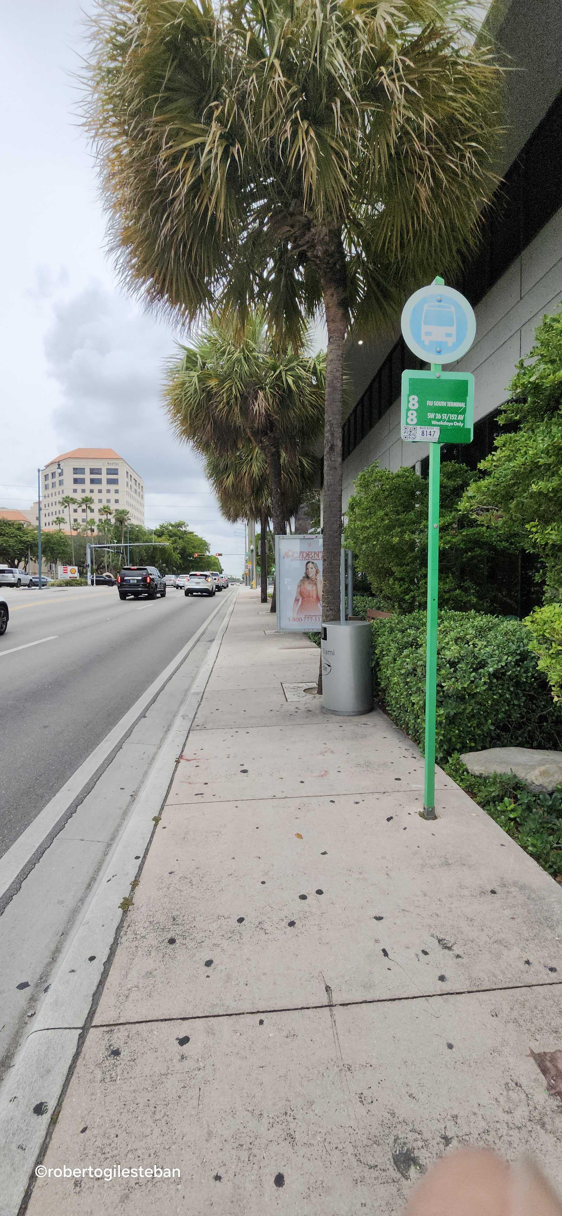 Taken by Roberto G.
See Sw 8 St @ Sw 36 Ct stop, Miami, on the map
Public transit to Sw 8 St @ Sw 36 Ct stop (ID: C8ST#368) in Miami
Looking for directions to Sw 8 St @ Sw 36 Ct in Miami, United States?
Download the Moovit App to find the current schedule and step-by-step directions for Bus or Train routes that pass through Sw 8 St @ Sw 36 Ct.
Looking for the nearest stops closest to Sw 8 St @ Sw 36 Ct ? Check out this list of closest stops to your destination: Oviedo Av@ponce De Leon Blvd; Sw 8 St @ Galiano St; Sw 37 Av @ Sw 9 Te; Sw 8 St & Sw 35 Av; Coconut Grove.
Bus: 37, 8, MIAHAVA, CGABLE.Train: GREEN, ORANGE.
We make riding on public transit to Sw 8 St @ Sw 36 Ct easy, which is why over 1.7 billion users, including users in Miami trust Moovit as the best app for public transit.
Use the app to navigate to popular places including to the airport, hospital, stadium, grocery store, mall, coffee shop, school, college, and university.
Sw 8 St @ Sw 36 Ct stop’s code is C8ST#368
The first line to this stop is 8, at 6:21 AM, and the last line is 8 at 11:41 PM.
3663 Sw 8th St, Miami, FL, USA
This stop serves Miami-Dade Transit’s lines
Popular routes from Sw 8 St @ Sw 36 Ct stop, Miami
- Oviedo Av@ponce De Leon Blvd,
- Sw 8 St @ Galiano St,
- Sw 37 Av @ Sw 9 Te,
- Sw 8 St & Sw 35 Av
Bus stops near Sw 8 St @ Sw 36 Ct stop
- Coconut Grove
Train station near Sw 8 St @ Sw 36 Ct station
- Sw 27 Av @ Sw 8 St,
- Sunrise Lakes Drive North/Sunrise Lakes Drive West,
- PGA BLVD at PBS,
- Sw 147 Av & Sw 291 St,
- Ne 79 St & Biscayne Blvd,
- W Flagler St & Sw 44 Av,
- Sunrise Boulevard/Nob Hill Road,
- W 12 Av & W 37 St,
- Sw 7 St @ Sw 17 Av,
- Cleveland Clinic Weston,
- BELVEDERE RD at MERCER AVE,
- FOREST HILL BLVD at HAVERHILL RD W,
- Mystic Pointe 350,
- VA MEDICAL CENTER (WPB),
- Transitway & Sw 328 St,
- Nw 42 Av & Nw 128 St,
- MILITARY TRL at 10TH AVE N,
- Sw 56 St & Sw 102 Av,
- Nw 21 St & Nw 37 Av,
- LAKE WORTH RD at KIRK RD
Popular public transit stations in Miami
Get around Miami by public transit!
Traveling around Miami has never been so easy. See step by step directions as you travel to any attraction, street or major public transit station. View bus and train schedules, arrival times, service alerts and detailed routes on a map, so you know exactly how to get to anywhere in Miami.
When traveling to any destination around Miami use Moovit's Live Directions with Get Off Notifications to know exactly where and how far to walk, how long to wait for your line, and how many stops are left. Moovit will alert you when it's time to get off — no need to constantly re-check whether yours is the next stop.
Wondering how to use public transit in Miami or how to pay for public transit in Miami? Moovit public transit app can help you navigate your way with public transit easily, and at minimum cost. It includes public transit fees, ticket prices, and costs. Looking for a map of Miami public transit lines? Moovit public transit app shows all public transit maps in Miami with all Bus, Train, Light Rail and Ferry routes and stops on an interactive map.
Miami has 4 transit type(s), including: Bus, Train, Light Rail and Ferry, operated by several transit agencies, including Broward County Transit, Miami-Dade Transit, Metrorail, Palm Tran, Tri-Rail, Brightline, MARTY, City of Homestead Trolley, Key West Transit, Treasure Coast Connector, GoLine IRT, Amtrak, Greyhound-us, FlixBus-us and Aventura Express Shuttle Bus